The need for development and economic growth must be carefully balanced against the impact that industries make on the environment. Decision-makers need to know if the potential benefits of any given development outweigh the likely negative impacts it will have on the environment and on society. Environmental Impact Assessment (EIA) is a tool used in Namibia and most other countries to promote sustainable development by evaluating the environmental and social impacts arising from development projects. The EIA process also encourages broad public engagement, by both specialists and the general public, and particularly by people and communities who could be impacted by the proposed development.
The Namibian public is becoming increasingly concerned about the effectiveness of the EIA processes, its administration and consequent decisions. Public trust in the EIA process seems to be at an all-time low, with many complaints and protests occurring after development projects have been given the green light. One high profile example of this is ReconAfrica's exploratory drilling for oil in the Okavango Basin despite local and international protests. In another case, Xinfeng Investments mining company was accused of illegal mining activities around Omaruru, leading to community demonstrations. A further example is the proposed in-situ uranium leach mining in the Kalahari aquifer system in the Leonardville – Stampriet area, which could have devastating consequences for the entire Kalahari aquifer system.
It is against this backdrop that the Namibian Environment and Wildlife Society (NEWS) and the Namibian Chamber of Environment (NCE) created the EIA Tracker. This system is more transparent and user-friendly than the system used by the Ministry of Environment Forestry and Tourism (MEFT) under the Office of the Environmental Commissioner. EIA information disappears from the MEFT website after some time, while some important documents are not publicly available. The new EIA Tracker ensures that all relevant information for each project is easy to find and will remain permanently in the public domain. It is in line with the Access to Information (ATI) Act, which seeks to compel public and private entities to make information available proactively and promptly.
The EIA Tracker project officially started in May 2023 while the website was opened to the public on the 2nd of November 2023. This online tool will promote transparency within the EIA sector, increase independent monitoring of high-risk projects and assist the public to engage constructively in the EIA process.
Source and synthesis of data in the EIA Tracker
By law, developers must advertise their projects in Namibian national newspapers to inform the public. The NCE collects the EIA information presented in these newspaper adverts and shares it through a mailing list. Additional information is gleaned from the MEFT Environmental Clearance Certificate (ECC) website. We follow up on every EIA advertised, requesting to be registered as an Interested or Affected Party, which grants us access to further information about the projects provided from the relevant developer and Environmental Assessment Practitioner. All of this information is then combined to create a database which is accessible from the EIA Tracker website.
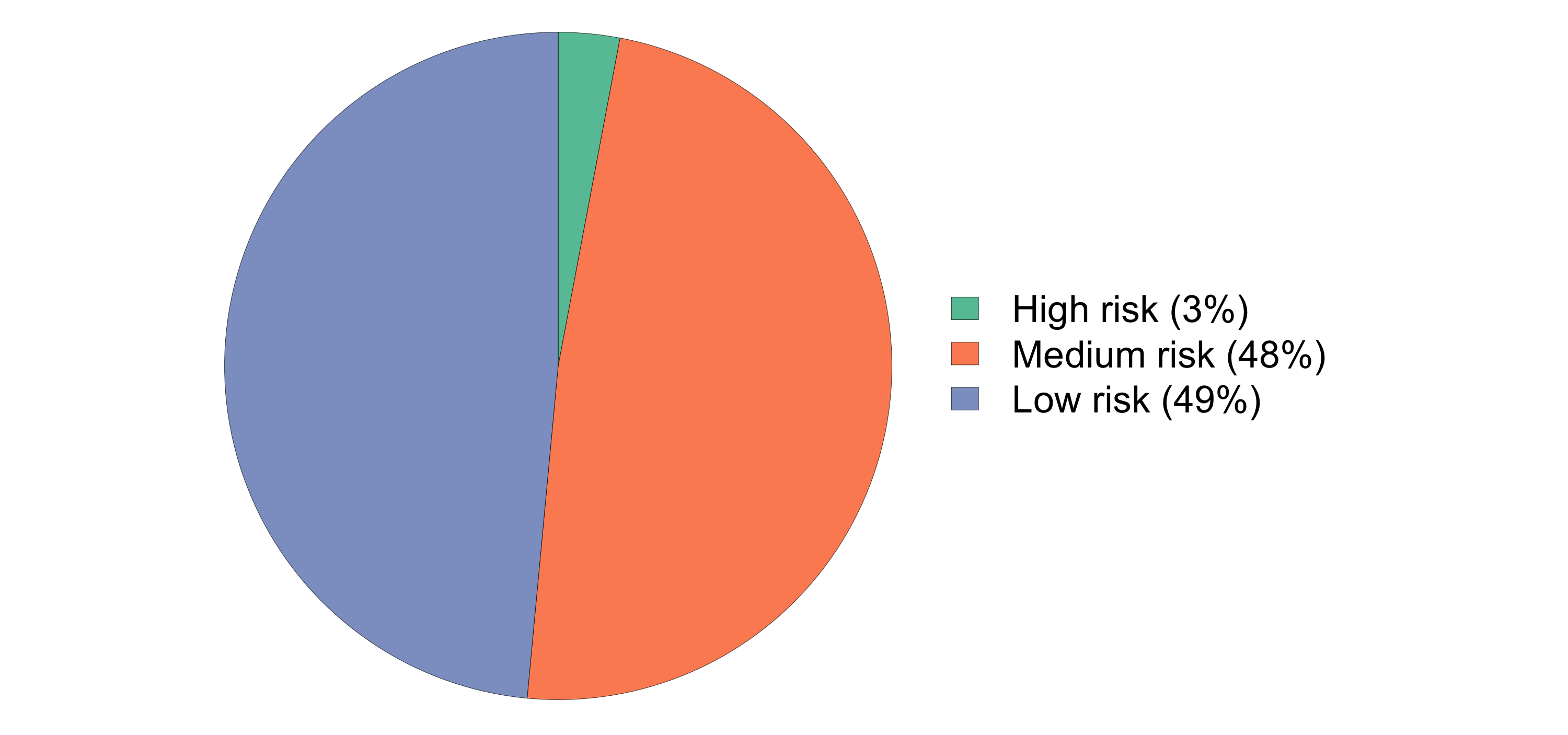
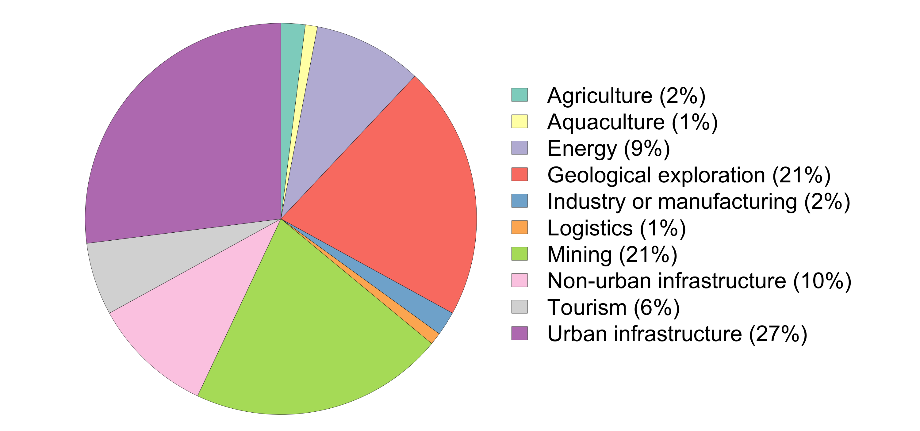
One advantage of this new database is that we can synthesise the information to gain insight into the state of EIAs in Namibia. For example, out of 615 EIAs recorded on the system to date, only 2.6% were assessed as being potentially high-risk projects. Most of the projects related to urban development, rezoning, fuel stations, low-risk mining (including sand mining), and geological exploration.
| Risk rating | Criteria | Examples |
|---|---|---|
| High | Significant impact on biodiversity, especially high priority species. High pollution risk. High risk to water resources | Large mines. Oil and gas exploration. Storage of hazardous chemicals e.g. for mining |
| Medium | Medium impact on biodiversity. Medium pollution risk. Medium risk to water resources | Small mines. Geological explorations. Storage of petroleum products. Fuel stations. Transmission powerlines. |
| Low | Low risk to biodiversity. Low pollution risk. Low risk to water resources. | Urban infrastructures, rezoning. Sand mining. Water supply |
Features of the EIA Tracker
The EIA Tracker website presents data in a map and a table that provide a brief overview of the EIA information associated with each project. The map includes relevant boundaries of different land uses in Namibia, e.g. state, communal and private protected areas, internationally recognised biodiversity hotspots or heritage sites. Users can choose which boundary layers to display on the map and thus determine which protected areas or farms could be impacted by proposed development projects.
The information stored in this database is permanently available and searchable according to key details such as deadlines for public input, projects status, level of risk, Environmental Assessment Practitioner (EAP) and the proponent's name (i.e. the developer). Projects are categorised according to the type of development (e.g. mining, tourism, urban, agricultural), which are represented by different icons on the map.
The status of each project (e.g. EIA underway or on hold, ECC approved or rejected) is displayed using different icon colours. Projects are rated according to their level of environmental risk according (see table). Areas subject to more than one EIA are marked on a green-red scale to show hotspot (red) areas that are subject to numerous development proposals.
The map thus provides a comprehensive and detailed picture of the state of EIAs across Namibia. Zooming in on the map provides increasing levels of detail. The EIA Tracker is therefore useful for people who are affected by particular development projects, organisations that are concerned about certain areas or types of activities, or those wanting to monitor development projects and EIA processes across the country.

Conclusion
The EIA Tracker provides a public platform for EIA information, which enables all Namibians to shine a light on controversial or high-impact projects. This is in the interest of improving overall environmental management by promoting a democratic and transparent process for EIAs. When the public is fully engaged with development projects they are more likely to have sustainable and socially acceptable outcomes. The end result is sustainable development, whereby Namibia is able to grow its economy and increase job creation for the current generation without jeopardising our environment and the welfare of future generations.
If you enjoyed this page, then you might also like:

For articles on similar topics, please click one of the following options:

We use cookies to monitor site usage and to help improve it. See our Privacy Policy for details. By continuing to use the site, you acknowledge acceptance of our policy.